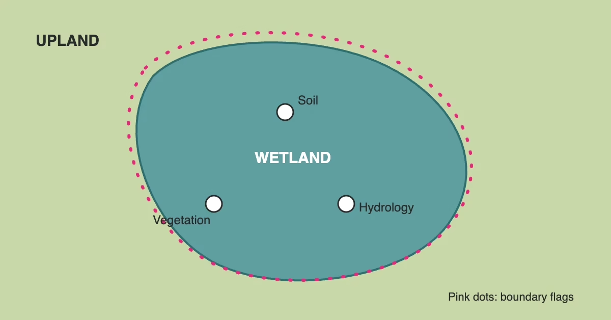
A wetland delineation is the field and paper work that finds out whether a property has a wetland and, if it does, marks exactly where the wetland ends and the upland begins. A3 Environmental Consultants (A3E) works in four parts: a desktop review of maps and databases, fieldwork, a written report, and a jurisdictional determination from the regulators. A full delineation starts around $3,500 and the fieldwork usually takes 10 to 15 business days. The regulators’ answer is the slow part.
If you are reading this, there is a good chance you own vacant land or are about to buy some. You want to build on it, and you want to know whether a wetland will take up room you were counting on. You may also want to know what happens if you disturb one. This guide answers those questions in the order they come up. If you have more, call us.
What Is a Wetland Delineation?
The word “delineation” is the key. A wetland delineation defines the boundary between the wetland and the upland around it. To count as a wetland, an area has to have all three of the proper soil, vegetation and hydrology. If one is missing, it is not a wetland. There is a small caveat: on farmland, or where a wetland was intentionally destroyed, you may still have a wetland.
That three-part test is why the work happens in the field and not from a desk alone. A map can suggest a wetland. Only a scientist standing on the property digging, looking and recording data can prove one is there, or prove it is not.
The Four Parts of a Wetland Delineation
1. Desktop Analysis
The first step is to check the Geographic Information Systems (GIS) and databases for the target parcel. We look at:
- ArcGIS Clearinghouse and the Illinois State Geological Survey (ISGS) Clearinghouse
- Natural Resources Conservation Service (NRCS) data
- Federal Emergency Management Agency (FEMA) flood maps
- The US Fish & Wildlife Service National Wetlands Inventory
- The USDA Web Soil Survey
- Topographic maps and Google Earth
We find the property on each map and check whether it is a known wetland, floodplain or floodway. We also do rainfall determinations on the aerial imagery and review the antecedent precipitation for the field workdays, to learn whether we are in a normal, wet or dry season.
2. Fieldwork
Next, field scientists go to the property and document the data needed to prove that a wetland exists or does not. They walk the property and mark the perimeter of each wetland with flags that look like utility locate flags. That flagged line is the delineation.
3. The Wetland Delineation Report
The wetland delineation report has three parts. Reports are typically about 50 pages and include narrative, photos and the results of the desktop analysis.
- Methods: when the fieldwork was done, what resources we used and what we did in the field.
- Results: what was found at each data point, in scientific terms.
- Conclusions and Discussion: the size and quality of the wetland we found, if any.
For a closer look at what goes into the document, see our article on the wetland delineation report.
4. Jurisdictional Determination
We do this work to comply with the agencies that manage wetland permitting. There are two main ones: the Army Corps of Engineers and the county stormwater agency. Cities work with their counties to set city ordinances, or they default to the county. The Army Corps is the top agency. Counties and cities can be more stringent than the Corps, but not more lax.
The wetland delineation report is built to be submitted to the Army Corps, which either agrees or disagrees with the consultant’s findings. A parcel that has been delineated ends up in one of three states:
- No wetland found: the consultant did not find all three indicators of soil, vegetation and hydrology.
- Regulated wetland: a wetland was found, in a location that makes it regulated by the Army Corps.
- Isolated wetland: not regulated by the Army Corps, but in the Chicago metropolitan area it may well be regulated by a local agency such as the county or city.
The Corps’ answer is covered in detail in our guide to wetland permitting and the jurisdictional determination request, and in how you know what a jurisdictional wetland is.
How Long Does a Wetland Delineation Take?
The fieldwork and report can be done in 10 to 15 business days, depending on weather and access to the property. Getting a determination from the Army Corps is, unfortunately, the longest part. It typically takes 45 to 60 days to get an answer for a nationwide permit, which covers most activities and wetland impacts. An individual permit needs a unique review of development plans and major impacts on wetlands, and it may take longer. After you have the Corps’ answer, it can take another two to four weeks or more to get a permit from the county or local government.
What Does a Wetland Delineation Cost?
A full delineation starts around $3,500. It can cost more depending on the size of the property, the predicted wetland pockets and the distance we need to travel. For a line-by-line look at price, read how much a wetland delineation costs.
If permitting is not the goal yet, there are lighter and cheaper options:
- Map and database review: $950. We review all the maps and databases and give you an opinion based on the data. This is the wetland screen.
- Wetland Confirmation: an additional $600 to $1,200. We send a scientist to the property to look for the telltale signs of a wetland.
Both are good due diligence steps before you buy a property you intend to build on, when you are not yet sure you need to submit a report to regulators.
Which Wetland Service Do You Need?
A3E offers the steps as separate services, so you can buy only as much certainty as the project needs:
- Wetland screens for a fast, inexpensive answer from maps and databases.
- Wetland confirmations when you need someone on site looking for the signs.
- Wetland delineations when you need a flagged boundary and a report for the regulators.
- Jurisdictional wetland determinations when you need the Army Corps’ answer on a regulated wetland.
What If You Want to Build on a Property With a Wetland?
The easiest way to build on a property that has a wetland is to avoid building over the wetland. A delineation shows you exactly where the boundary is, so you can see how much room you have. The second way is to get the appropriate permits, which may involve wetland mitigation.
A wetland is often also a warning sign for the building site. Wetlands usually sit at the lowest point on a property, so they show you where it is likely to flood and where soils may not hold up under a heavy building. If the regulators do not stop you from building over one, your geotechnical or structural engineer may.
Project Example: A 23-Acre Delineation in Lisle
In 2024, A3E delineated the wetlands on a 23-acre mixed-use site in Lisle, DuPage County, Illinois. After a desk review, field work ran in June and July 2024. We found three wetlands: a drainage swale to the DuPage River, a constructed stormwater pond, and an area believed to be a protected mitigation wetland. None was rated critical, and the EcoCAT review was clear. DuPage County staff verified the boundaries on August 7, 2024.
- Project: Wetland delineation, 23-acre mixed-use site (2024)
- City: Lisle, DuPage County, Illinois
- Outcome: three wetlands mapped; boundaries verified by DuPage County
Frequently Asked Questions
What is a wetland delineation?
A wetland delineation is a study that decides whether a property has a wetland and marks the boundary between the wetland and the upland. An area must have the proper soil, vegetation and hydrology to qualify.
How long does a wetland delineation take?
The fieldwork and report can be done in 10 to 15 business days, depending on weather and access to the property. The Army Corps determination typically adds 45 to 60 days for a nationwide permit, and a county or local permit can take another two to four weeks or more.
What does a wetland delineation cost?
A full delineation starts around $3,500 and can cost more with a larger property, more predicted wetland pockets or longer travel. A map and database review is $950, and a Wetland Confirmation adds $600 to $1,200.
Which laws protect wetlands in Illinois?
At the federal level, the Clean Water Act gives the Army Corps its permitting authority. Illinois adds the Interagency Wetland Policy Act of 1989 for state-funded projects, and counties and cities layer their own stormwater rules on top.
Can I build on a property with a wetland?
Yes, if you avoid building over the wetland, or if you get the appropriate permits, which may involve wetland mitigation.
Call A3E for Wetland Delineation and Due Diligence
Whether it is a wetland screen, a confirmation, a delineation or a jurisdictional determination, A3E can get your project done. Request a wetland delineation quote, call (888) 405-1742 or email [email protected] and let’s talk about your project.
Reviewed by Dave McCoy, P.G., Director of Operations, A3 Environmental Consultants.

We Fix Gnarly Environmental Problems
