
Wetland Delineation Cost: What You Will Pay in 2026
A wetland delineation cost starts at approximately $3,500 for a standard project in Illinois and can range up to $8,000 or more depending on site size, complexity, and permitting requirements. The total wetland delineation cost breaks down into four components: a wetland screen ($1,000), field survey ($1,000+), delineation report ($1,000+), and permitting ($600+). Each builds on the previous step, and you may not need all four.
If you already know you need a wetland delineation and want a project-specific quote, call A3 Environmental Consultants at (888) 405-1742. For everyone else, here is exactly how wetland delineation cost is determined and where your money goes.
Wetland Delineation Cost Breakdown
Every wetland delineation project is different, but the cost components are consistent. A3E unbundles these so you only pay for what your project requires.
| Component | What It Covers | Typical Cost |
|---|---|---|
| Wetland Screen | Desktop review of databases, maps, NWI, soils data | ~$1,000 |
| Field Survey | On-site inspection, flagging, GPS mapping | $1,000–$3,000+ |
| Delineation Report | Written report suitable for Army Corps review | $1,000–$2,000+ |
| Wetland Permitting | Section 404 permit application and agency coordination | $600–$1,500+ |
Total wetland delineation cost for a typical project: $3,500–$8,000+
Wetland Screen Cost (~$1,000)
The wetland screen is the starting point. Our scientists review all available data sources — the National Wetland Inventory (NWI), USDA soil survey maps, aerial photographs, topographic maps, FEMA floodplain data, and state databases — to predict whether wetlands are likely present on the property and where they may be located.
This desktop analysis produces a detailed report that either stands alone (if a screen is all you need for due diligence) or informs the field work phase. Many real estate transactions and preliminary site assessments only require a wetland screen, making this the most cost-effective option when you need to know if wetlands are a factor before committing to a full delineation.
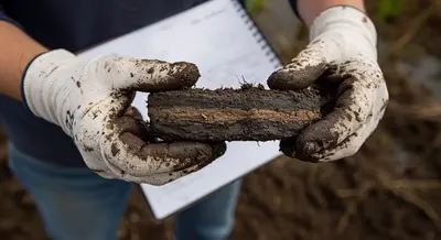
Examining hydric soil indicators during a wetland delineation field survey
Wetland Survey Field Work Cost ($1,000–$3,000+)
The field portion of a wetland delineation is where the real cost variability comes in. Our certified wetland delineators go to the site to either determine the presence of wetlands or delineate their exact boundaries. The difference matters:
- Wetland determination: Confirms whether wetlands exist on the property. Lower cost, faster turnaround.
- Wetland delineation: Maps the precise boundary between wetland and upland, plots GPS coordinates, and collects vegetation, soil, and hydrology data at multiple sample points. Required for jurisdictional wetland determinations and permit applications.
Field work cost depends on three factors:
- Site size — A 2-acre lot takes one person half a day. A 50-acre parcel may need a two-person crew for multiple days.
- Site complexity — Multiple wetland types, dense vegetation, or difficult terrain increase time on-site.
- Travel distance — A3E staff travel time to and from the site is part of the field work cost. A local project in northern Illinois minimizes this. A remote downstate site adds hours.
For a typical 5–10 acre site with one wetland delineator, expect roughly one full day of field work including travel — approximately $1,000–$1,500 for the field portion alone.
Wetland Delineation Report Cost ($1,000–$2,000+)
The delineation report is the deliverable your project depends on. It memorializes everything from the desktop review and field investigation into a format that satisfies the U.S. Army Corps of Engineers and state regulatory agencies.
A complete wetland delineation report includes:
- Site description and project background
- Desktop analysis findings (NWI, soils, aerials, databases)
- Field methodology and data point locations
- Vegetation, hydrology, and soil sampling results
- Wetland boundary maps with GPS coordinates
- Conclusions and jurisdictional determination recommendations
A skilled report writer with wetland delineation credentials compiles this in roughly 8–16 hours depending on project complexity. The wetland screen forms the first chapters, field data makes up the middle sections, and conclusions tie it together.
Wetland Permitting Cost ($600–$1,500+)
If your project will impact jurisdictional wetlands, you need permits before any work begins. A3E handles the permitting process, including:
- Section 404 permit applications to the U.S. Army Corps of Engineers
- County stormwater agency submittals
- State agency coordination (Illinois EPA, IDNR)
- Requesting a jurisdictional determination letter — the document that confirms wetland boundaries and allows your project to proceed
Permitting costs vary based on the type of permit required (nationwide vs. individual) and the number of agencies involved. Basic permitting starts around $600 for straightforward nationwide permits and increases for complex projects requiring individual permits or mitigation plans.
What Affects Your Total Wetland Delineation Cost?
Beyond the four core components, several factors push the wetland delineation cost higher or lower:
- Property size: Larger sites require more sample points, more field time, and longer reports
- Number of wetland types: A site with forested wetland, emergent marsh, and seasonal pools requires more data collection than one with a single wetland type
- Regulatory complexity: Projects involving multiple agencies (Corps, county, state, FEMA) cost more in permitting
- Mitigation requirements: If wetland impacts cannot be avoided, mitigation banking or on-site mitigation design adds significant cost
- Seasonal timing: Growing season surveys (May–October) produce the best vegetation data. Off-season work may require follow-up visits.
A3E Wetland Delineation: Lisle, Illinois Project
A3 Environmental Consultants completed a wetland delineation for a development project in Lisle, Illinois (41.7981°N, 88.0748°W). The project involved delineating wetland boundaries on a multi-acre parcel, collecting vegetation and soil data at multiple sample points, and producing a delineation report for Army Corps review. Our certified wetland delineators, led by Alisa Allen, P.G., completed the field work and delivered the report within the client’s development timeline.
Read the full Wetland Delineation Project Profile — Lisle, Illinois.
Frequently Asked Questions About Wetland Delineation Cost
How much does a wetland delineation cost per acre?
Wetland delineation cost per acre varies widely, but a rough estimate is $500–$1,500 per acre for the field work and report combined. Smaller sites cost more per acre because fixed costs (mobilization, travel, report setup) are spread over fewer acres. Large sites benefit from economies of scale but require more field time and data points.
How long does a wetland delineation take?
A typical wetland delineation takes 2–4 weeks from start to finished report. The wetland screen takes 2–3 days, field work takes 1–3 days depending on site size, and the report takes 1–2 weeks to compile. Permitting timelines vary — Army Corps reviews can take 30–120 days depending on permit type and workload.
Do I need a wetland delineation before building?
If your property contains or may contain wetlands, a delineation is typically required before you can obtain building permits or begin grading. Disturbing jurisdictional wetlands without a permit violates the Clean Water Act and can result in significant fines, project delays, and mandatory restoration. A wetland screen is the most cost-effective first step to determine if a full delineation is needed.
Who pays for a wetland delineation?
The property buyer or developer typically pays for the wetland delineation as part of their due diligence or permitting process. In real estate transactions, the cost is sometimes negotiated between buyer and seller. For public projects, the sponsoring municipality or agency covers the cost. See our article on who pays for environmental assessments for more context.
Can I do a wetland delineation myself?
The Army Corps of Engineers requires wetland delineations to follow the 1987 Corps Wetland Delineation Manual and applicable regional supplements. While no law prevents you from conducting your own delineation, the Corps and permitting agencies typically require the work to be performed by qualified professionals with demonstrated expertise in wetland identification, soil science, and hydrology. Reports from unqualified individuals are routinely rejected, costing more in the long run.
Need a wetland delineation cost estimate for your project?
Contact A3 Environmental Consultants or call (888) 405-1742 for a free consultation.

We Fix Gnarly Environmental Problems
Reviewed by Alisa Allen, P.G.


