Watershed Plan development is the foundation of effective water quality restoration in Illinois. A well-built Watershed Plan identifies pollution sources, proposes science-based solutions, and creates the roadmap that unlocks federal funding — including IEPA Section 319(h) grants. Without an EPA-approved Watershed Plan, most communities cannot access implementation funding for streambank stabilization, buffer installation, or habitat restoration.
A3 Environmental Consultants (A3E) led the development of the Winneshiek Creek Watershed Plan in Stephenson County, Illinois — a multi-year, community-driven initiative that produced an EPA-approved plan now serving as a model for other rural Illinois watersheds.

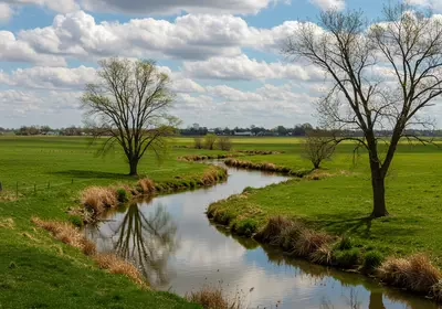
Winneshiek Creek winds through agricultural land east of Freeport, Illinois
What Is a Watershed Plan?
A Watershed Plan is a technical document that characterizes a watershed’s conditions — hydrology, land use, soil types, water quality, habitat, and demographics — and recommends specific actions to address impairments. In Illinois, watershed plans developed under EPA guidelines for Section 319 of the Clean Water Act must include nine required elements, including pollutant load estimates, measurable milestones, and an implementation schedule with identified funding sources.
A completed Watershed Plan serves multiple purposes. It qualifies the community for 319(h) implementation grants. It provides municipalities with a defensible technical basis for stormwater ordinances and capital planning. And it creates a shared framework that aligns landowners, conservation districts, park districts, and local government around common water quality goals.
Winneshiek Creek: Building the Watershed Plan
The Winneshiek Creek watershed covers approximately 10,000 acres east of Freeport, Stephenson County, Illinois (42.2967°N, 89.5812°W). The watershed is home to around 1,000 residents in a mixed-use landscape of agricultural fields, residential properties, and riparian corridors along the creek.
In 2019, the Natural Land Institute (NLI) initiated the Watershed Plan process by partnering with Olson Ecological Solutions (OES) — now part of A3 Environmental Consultants — and Tallgrass Restoration (TGR) to create a comprehensive watershed inventory. This baseline assessment covered land use patterns, hydrology, soils, climate data, water quality monitoring results, and community demographics.
Stakeholder planning sessions shaped the Watershed Plan goals
Community-Driven Watershed Plan Process
Starting in 2021, OES led 12 structured stakeholder meetings plus a final implementation kickoff session. These meetings engaged local residents, landowners, municipal officials, and conservation partners in identifying priorities and setting goals for the Watershed Plan.
Key issues identified through the stakeholder process included:
- Nonpoint source pollution from agricultural runoff and lawn fertilizer
- Streambank erosion accelerated by altered hydrology and land use changes
- Wildlife habitat degradation along riparian corridors
- Limited recreational access to the creek and surrounding natural areas
- Invasive species encroachment displacing native vegetation
This inclusive approach distinguished the Winneshiek Creek effort from top-down planning models that often fail in rural communities. Residents who participated in the visioning sessions could see their input reflected in the final recommendations — creating a sense of ownership that drives voluntary adoption of best management practices on private land.
The stakeholder-driven approach was critical to the Watershed Plan’s success. Because implementation relies on voluntary landowner participation — not regulatory mandates — the plan needed community buy-in from the start. By involving residents in goal-setting and BMP selection, the planning team built the social infrastructure needed for long-term adoption.
Watershed Plan Recommendations
The finalized Watershed Plan recommended a suite of best management practices (BMPs) tailored to local conditions in Stephenson County:
- Vegetative buffer strips along agricultural fields and streambanks to capture sediment and nutrient runoff before it reaches the waterway
- Streambank stabilization using bioengineering techniques — live stakes, coconut fiber logs, and native plantings — at high-erosion sites
- Riparian corridor restoration to reestablish native trees, shrubs, and understory vegetation along Winneshiek Creek
- Cover crop promotion on agricultural parcels to reduce seasonal soil exposure and nutrient loss
- Conservation easement outreach to protect high-value ecological areas from future development
- Trail and access improvements to increase community connection to the watershed and build long-term stewardship
Each recommendation included estimated pollutant load reductions, implementation timelines, responsible parties, and potential funding sources — meeting all nine EPA-required elements for Section 319 compliance. The plan also included a detailed implementation schedule spanning 10 years, with phased priorities allowing the community to pursue early wins — like buffer strip installations on willing landowners’ properties — while building momentum for larger capital projects like streambank stabilization.
Buffer strips reduce nonpoint source pollution reaching waterways
Why a Watershed Plan Matters for Your Community
The plan is more than a technical document — it is a strategic investment. Communities with EPA-approved watershed plans gain:
- Access to federal funding: 319 Grant implementation funding requires an approved plan as a prerequisite
- Defensible planning basis: Municipalities can reference the plan in stormwater master plans, comprehensive plans, and capital improvement budgets
- Grant competitiveness: Applications for IEPA, USDA, and other environmental grants score higher when supported by an existing approved plan
- Stakeholder alignment: The planning process itself builds the community relationships needed for voluntary BMP adoption
- Measurable outcomes: Quantified load reduction targets allow communities to track progress and demonstrate results to funders
The Winneshiek Creek document was adopted by the IEPA as a compliant Section 319 plan, positioning the community for future implementation funding. This is a direct path to construction dollars: once the IEPA recognizes a watershed plan, the community can apply for implementation grants that fund the BMPs recommended in the plan — typically at 60% federal cost share.
A3E Watershed Plan Experience
A3 Environmental Consultants has authored seven watershed plans across northern Illinois, each receiving EPA approval. The firm’s watershed planning capabilities include:
- Watershed inventory and characterization (hydrology, land use, water quality, habitat)
- Stakeholder facilitation and community engagement
- Pollutant load modeling and BMP effectiveness analysis
- EPA nine-element plan development
- Stormwater management integration
- Ecological services including wetland delineation, restoration, and monitoring
- Grant writing for 319 Grant implementation funding
Frequently Asked Questions
What is a Watershed Plan?
It is a science-based document that assesses conditions in a drainage area, identifies sources of water quality impairment, and recommends actions to restore and protect the watershed. In Illinois, plans developed under EPA Section 319 guidelines must include nine required elements covering pollutant sources, load reductions, BMPs, timelines, and funding.
How long does it take to develop a Watershed Plan?
Most watershed plans take 2 to 4 years from initiation to EPA approval. The Winneshiek Creek plan began with inventory work in 2019 and was finalized in 2025. Timelines depend on watershed size, stakeholder engagement scope, and data availability. Smaller watersheds with existing data may complete in 18 months. Larger or more complex watersheds with extensive stakeholder processes — like Winneshiek Creek — may take 3 to 5 years from initiation to EPA approval.
Who pays for a Watershed Plan?
IEPA Section 319 planning grants fund watershed plan development, typically covering 60% of costs with a 40% non-federal match. Lead applicants are usually municipalities, counties, soil and water conservation districts, or qualified nonprofits like the Natural Land Institute.
Does the plan require regulatory compliance?
No. Watershed plans developed under Section 319 are voluntary frameworks — they do not impose regulations on landowners. Implementation depends on voluntary BMP adoption, incentive programs, and grant-funded projects. This voluntary nature is a key strength, as it builds community support rather than resistance.
Can A3E develop a Watershed Plan for my community?
Yes. A3 Environmental Consultants has developed seven EPA-approved watershed plans in northern Illinois and provides the full range of services from initial inventory through stakeholder facilitation, plan writing, IEPA submission, and follow-on implementation support.
Get Started
Whether your community is addressing impaired waterways, preparing for grant applications, or building a long-term water quality strategy, a Watershed Plan is the essential first step. A3 Environmental Consultants has the experience and technical depth to guide your watershed from assessment through EPA-approved plan.
Contact A3E About Watershed Planning →
Call us at (888) 405-1742 or email Info@A3E.com.
Reviewed by Tim Allen, A3 Environmental Consultants

We Fix Gnarly Environmental Problems
